Monday, December 6, 2010

Dry Dock, Shipyards, and St. Brigid's


Throughout much of the 1800's, the east side of the Eleventh Ward (the official designation of the area we call the East Village) was an important center of shipbuilding.  In 1824, a group of shipbuilders came together as the New York Dry Dock Company to construct an inclined railway at the foot of East 10th Street to pull ships from the water for repair.  By 1844 there were shipyards extending along the East River from Grand Street to 12th Street.

The area became known as the "Dry Dock" district, or in some texts, simply "Dry Dock". (A dry dock is a large drainable basin used for building and/or repairing ships.) Dry Dock Street was located adjacent to the New York Dry Dock Company's facility.

1840: Detail from the Chapman and Hall map.  This is the earliest map I found that includes Dry Dock Street (between Avenues C and D and 10th to 13th Streets), as well as the labeled "Dry Dock".  Note the extension of Lewis Street (east of Avenue D), the remnant of which is today's Lillian Wald Dr.  Also note the grayed areas which seem to indicate developed areas of the street grid--much of the area directly surrounding Tompkins Square remains undeveloped.
Rumsey Collection

Among the notable shipbuilders of the era was William H. Webb, who built 133 ships (ranging from clippers to steamships) between 1840 and 1865 from his shipyard between 5th and 7th Streets.

1867: Detail from the remarkable Dripps map.  Dry Dock street has been trimmed back to 12th Street, and the William Webb shipyards are clearly marked.  In contrast with the Chapman and Hall map above, the entire ward has been developed.  Be sure to download the full-resolution version of this map!
Library of Congress

The area became the home for thousands of shipyard workers and their families.  In 1921, Justice L.A. Giegerich recalled his childhood in the Eleventh Ward of the 1860's:
Neat brick dwelling houses containing at most two families occupied the greater portion of the area lying between Third and Ninth streets and Avenue C and the East River and there were also many such houses in other parts of the ward.
Valentine's Manual of Old New York, 1921 Edition
The opportunities provided by the booming shipyards made the area a common landing point for Irish immigrants escaping the famine between 1845 and 1851.  Plans were made for a Catholic church to serve this community, and in September 1848, the cornerstone was laid for St. Brigid's (named for the patron saint of boatmen).  Designed by Patrick Keely, a noted designer of churches, the building on the southeast corner of Avenue B and 8th Street was dedicated in December 1849.

A view of St. Brigid's, c. 1928, looking across Avenue B from Tompkins Square Park.
NYPL Digital Gallery

Detail from the 1867 Dripps map showing St. Brigid's (labeled R.Ch.) on the corner of Avenue B and 8th Street.
Library of Congress

A recent view of St. Brigid's (from the Save St. Brigid web site).  The steeples were removed in 1962 due to structural concerns.

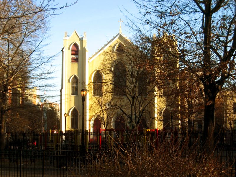
St. Brigid's recently survived a demolition scare and today is undergoing a massive restoration effort.  To see how you can help save this enormously historic structure, please visit Save St. Brigid.

Read more about the early history of St. Brigid's in The Catholic churches of New York City, with sketches of their history and lives of the present pastors (1878).

Extra credit: Find St. Brigid's in this extraordinary 1913 photo (hat tip to Shorpy's).

Today, Dry Dock Street remains, although its name was changed to Szold Place in 1951 to honor Henrietta Szold, founder of the women's Zionist organization, Hadassah.  The adjacent Dry Dock Playground & Pool is the only neighborhood reminder I could find of this once thriving industry.


An Interesting Artifact: Dry Dock Savings Institution

In 1848, the Dry Dock Savings Institution was incorporated to serve the growing population of Dry Dock. There was no other bank east of the Bowery at that time, so the bank grew quickly after opening in a two-story brick building on East 4th Street, just west of Avenue C. The bank merged with Dollar Savings Bank in 1983, and in 1992, Dollar Dry Dock failed due to losses from real estate loans.

The gothic Dry Dock Savings Institution building at Bowery and 3rd Street, designed by Leopold Eidlitz and erected in 1875 (demolished) was actually the bank's third location.
NYPL Digital Gallery

Other Maps 


1832: Detail from the Burr map of the Eleventh Ward.  This early map does not yet show the dry dock, or even Tompkins Square (which opened in 1834).  Also note how severely the shoreline encroaches as far west as Avenue B north of 10th Street.
Rumsey Collection

1846: Detail from the Mitchell map.  The Dry Dock and Dry Dock Street are clearly marked.
Rumsey Collection

Notable References and Original Sources


Tuesday, November 30, 2010

Update: An Amusing Headline, A Family Legend


If you missed the original post, this 1920 article in the New York Times tells the story of a parrot that awakens a tailor's family to a burglar, and the16-year-old daughter, Cecilia, who proceeds to chase him up the street.  The article confirms a bit of my family's lore:

New York Times, February 2, 1920

In the post, I noted some confusion over the article's report that Cecilia's address was 5 Chrystie Street.  The action in the story takes place around Pearl Street and New Bowery, and my grandfather had always said he was born and raised on Pearl Street.

After some investigation (thanks, ancestry.com), I get some answers.  Here is a bit of the 1920 census for the 4th Ward of Manhattan, recorded about a month before the Times article:


The highlighted section shows my father's family, the Shermans.  Here's a detail that clearly shows 16-year-old Cecilia, as well as 12-year-old Edward, my grandfather:


Brothers Alexander and Lawrence are not listed because they were in their twenties at the time and had already left home (they are both listed in the 1910 census).  Perhaps they were just visiting that day.

The number 397 (to the left in the detail) is the family's address on Pearl Street.  In fact, the census reports of 1910, 1920, and 1930 all show the family living at that address.  This is also, presumably, the address of the tailor shop.  So back to the 1911 Bromley map, where the 3-story building they lived in is clearly marked:

NYPL Digital Gallery

The building is also right in the middle of the action that takes place in the Times story.  Unfortunately, I still don't have answer for the 5 Chrystie Street address.  Could just be a reporter's mistake?


Waiting on a Friend


Ed. Note: Okay, so I assume everyone knows this, but just in case...

When I first moved to the East Village I spent most of my time at Downtown Beirut (best jukebox ever) and St. Marks Bar & Grill. I had been here maybe six months when I found myself chatting about the mural on the back wall at St. Marks, and how the Rolling Stones had filmed their video for Waiting on a Friend on St. Marks Place and in the bar itself, and how the band actually played a set in the bar.  I tried to pretend it was old news, but I'm a terrible liar. 

"Wait, you did know that, right?"

Mick walks and Keith staggers into the bar at St. Marks and First Avenue, looking north along the east side of the avenue, screen grab from the Waiting on a Friend video (filmed July 21, 1981, according to the Rolling Stones database).

The same view today.  (Author, 2010)

Another screen grab, the whole band inside the bar.  Ron Wood opened his own short-lived club not far away, on East 4th (west of Second Avenue), in 1990.

While researching this post, I learned something I hadn't heard before.  The video was directed by Michael Lindsay-Hogg, an early director of musical promo films (that came to be known as videos), whose credits include an extensive library of film, video, and television work, including the iconic video for the Beatles "Hey Jude."

A behind-the-scenes shot.  You can find more here.

There's plenty of other web content about this video shoot along St. Marks between First and A (as was the cover of Led Zeppelin's Physical Graffiti album, which everyone knows already, of course, right?), so I'll just direct you to Google for more info.

Or visit EV Grieve for info on the recent fire at the Physical Graffiti buildings.


Monday, November 22, 2010

Selling Baked Goods from the Grace Church Yard, and the Birth of the Bread Line


The cornerstone for Grace Church, the iconic landmark at Broadway and 10th Street, was laid on Oct 30, 1843. The land was purchased earlier that year from the estate of Henry Brevoort Sr. for $35,000. The church was designed by James Renwick (age 23 at the time, who later designed St. Patrick's Cathedral) and was consecrated in 1846.

Grace Church, c.1924, looking northeast with Broadway running uptown to the left and 10th Street to the right. Note the yard in the lower right of photo.
NYPL Digital Gallery

But Grace Church's land did not originally stretch to 10th Street as it does today. The lot on the northeast corner of Broadway at 10th Street, just over 39 feet wide, was the site of another well-known building of its day.

A view looking east across Broadway (uptown to the left) at Fleischmann's Vienna Model Bakery c. 1888. Note Grace Church to the left, and the snow of the Great Blizard of '88.
NYPL Digital Gallery

Louis Fleischmann and his brothers, Charles and Max, were Austrian immigrants who introduced "Vienna bread" at their "Vienna Model Bakery" at the 1876 Centennial Exhibition in Philadelphia. The bread and model bakery were a huge hit, and shortly afterwards Fleischmann opened a permanent bakery at 788 Broadway, on the corner of 10th Street.

The bakery and its attached cafe became a popular meeting place and destination for Ladies Mile shoppers (the bakery was located across 10th Street from the "Iron Palace" of A.T. Stewart and later Wanamaker's).  Vienna bread quickly spread around the city, becoming one of the city's earliest food fads.

Fleischmann and his bakeries expanded to other cities, while the yeast company bearing his brothers' name continues to this day.
But Fleischmann is also remembered for a form of charity with which he alone seems credited, the "bread line". As Fleischmann lay on his death bed in 1904 it was noted:
The idea of [the bread line's] establishment came to Mr. Fleischmann when he noticed a crowd of hungry tramps standing over the grating at the bakery at Tenth Street and Broadway, scenting the hot loaves that were being turned out in the basement. Mr. Fleishmann offered to feed one of the men, and soon a line formed.
New York Times (September 25 1904)

Illustration from an article about Fleischmann and the origin of his philanthropy, New York Times (October 2, 1904)

From then on, each night at midnight, a line would form around the block in front of Grace Church to which Mr. Fleischmann would distribute his unsold goods.  It was said that Mr. Fleishmann himself was often seen handing out loaves, along with hot coffee in the winter.

Shortly after Fleischmann's death in 1904, Grace Church acquired the property.

New York Times, February 27, 1906

After the bakery moved its operations to a new location at 11th Street between Broadway and University Place, the bread line continued for years.

A view of the Fleishmann's building c. 1908, shortly before it was demolished. Note the E.Weingarten's sign noting their imminent move to another location.  I always chuckle at the cross-armed police officer sternly watching the photographer, lower right.
NYPL Digital Gallery

Here's a similar view today, via Google Maps.

An Interesting Artifact: The Bend in Broadway

As legend has it, Henry Brevoort Sr., a prominent landowner of the early 1800's, fought the proposed path of Broadway laid out in the 1807 draft of the Commissioner's Plan because it cut directly though his land on a straight line to 23rd Street. It is said that Mr. Brevoort owned a favorite tulip tree under which he enjoyed relaxing and having a smoke. This tree, near the present intersection of Broadway and 10th Street, would need to be cut down to accommodate the new road. To save the tree, Broadway was angled in the direction we know today.

As documented in his fascinating graduate thesis, Reuben Skye Rose-Redwood details the incident that inspired the myth. In 1807, Mr. Brevoort and six other landowners petitioned the commissioners in a letter titled "Reasons of several land holders in Broad Way against the payment of the Sums assessed upon them for Opening the Same.” In fact, the landowners objections had more to do with monetary concerns rather than a tulip tree. The city gave in, the commission made its recommendations, and in 1815 the "bend" became law.

The image above is a detail from the famous Randel Farm Map c. 1819 superimposing the street grid with existing farm boundaries and showing the point where the Bloomingdale Road (the northern route of today's Broadway) meets lower Broadway at 10th Street, bisecting Henry Brevoort's property.

Reference: RATIONALIZING THE LANDSCAPE: SUPERIMPOSING THE GRID UPON THE ISLAND OF MANHATTAN, a thesis in geography by Reuben Skye Rose-Redwood.


References and Sources


New York Times Articles


Tuesday, November 16, 2010

A.T. Stewart, John Wanamaker, the Great Fire, and the Great Flood (Part II)


Ed. Note: If you missed Part I, you can check it out here.

In 1954, Wanamaker's announced it would close its store complex on the blocks between 4th Avenue and Broadway, 8th and 10th Streets, citing a new focus on suburban stores.  The older store, the 1862 A.T. Stewart "Iron Palace" was already being used as offices, having been leased to the U.S. Goverment some years earlier.  In December 1954, the store closed its doors.

In March 1956, a group acquired the site of the "Iron Palace" with plans to build a complex of 478 apartments.  Demolition began a few months later, scheduled to take four months.  Then on July 14, a massive fire broke out.


An amazing newsreel from British Pathé. Click the image to view the video, or go here to launch the video on its own page.

The Times reported the blaze took 25 hours to control with 187 firefighters hurt.  The Broadway BMT subway (today's N/R) and the Lexington IRT (today's 4/5/6) were closed, as were the surrounding streets, including Broadway and 4th Avenue.  Thousands of site-seers surrounded the site to catch a glimpse of the calamity:
There was plenty to see...The area within Twelfth Street on the north, Eighth Street and Astor Place on the south, University Place on the west and Third Avenue on the east resembled a hastily constructed battle scene...From the gray stone pile of the Wanamaker building, which resembled a gaping, bombed-out shell, billowed acrid smoke, intermittently shot through with licks of flame.
New York Times, July 16, 1956

Crowds gather to watch the fire in two shots by photographer Robert Frank.

The top photo seems to be taken from 9th Street at 4th Avenue looking downtown (note the Cooper Union Foundation Building in the background).
I haven't been able to pinpoint this second photo, although I have some ideas. Guesses?

With an estimated 50,000,000 gallons of water used on the fire, the Astor Place station was completely flooded.  The track foundation for the IRT line was washed away, and the Transit Authority feared that 4th Avenue might itself collapse.  The BMT and IRT lines were completely shut down for two days and normal service was not restored for five days.  A week later, 4th Avenue remained closed from 8th Street to 11th Street as repairs continued.

July 1956: A great shot of the construction activity in Astor Place after the flood, taken from the northwest corner of 9th Street and 4th Avenue.  Note the scaffolding at the far left from the demolition of another landmark, Bible House, underway at the same time.  Also note the billboard advertising the 1955-56 World's Fair in the Dominican Republic instead of the Coca-Cola display made famous by Rudy Burckhardt.
The Miracle of Astor Place, Transit Magazine, November 1956

Foundation work for the Stewart House apartments began in April 1959 and the project was completed in 1960.


A view of Wanamaker's "new building" in 1933.  This view looks west across 4th Avenue and Lafayette Street. The building survives today as 770 Broadway and home to KMart.
Ryerson & Burnham Collection

Here's the building today.

Some stills worth noting from the British Pathé newsreel:
  • At 0:36: Appears to be looking down Broadway (east side) across 8th Street at the corner where the Gap now stands (it was a Manhattan Savings Bank in 1956).
  • At 0:42: A ghostly image looking up 4th Avenue from 9th to 10th Streets, note the shadow of the Con Ed tower in the upper right.

New York Times References


Coverage of the Wanamaker's store closing and sale by the New York Times:
Coverage of the Wanamaker's fire by the New York Times, July 15-19, 1956:


Monday, November 15, 2010

Sleepers

In 1996, the Barry Levinson film Sleepers opened with an all-star cast and good reviews.  A scene that establishes the story involves a hot dog cart careening down the stairs of a subway station.  If you look closely, you'll see the scene was filmed at the Astor Place station.  Note the period of the cars and dress; the scene takes place in the mid/late 60's.  Some screen grabs are below.

The kids push the stolen hot dog cart around the corner at 9th Street, headed downtown on 4th Avenue.  You can see Chris French Cleaners on Google.

A view from the bottom of the stairs at the uptown side of the Astor Place station, looking up at the kiosk.

The kids struggle to keep control of the cart.  Note the Wanamaker's building (770 Broadway) and the Stewart House apartments in the background.

I wonder if I'm the only one who found it amusing that these kids pushed that cart all the way from Hell's Kitchen (where they lived) to Astor Place.  Or is that what they mean by "suspension of disbelief."

You can see this scene on YouTube.  Look for an effects shot that makes a downtown view of Astor Place look like Times Square.


Friday, November 12, 2010

Coming Soon...

  • A.T. Stewart, John Wanamaker, the Great Fire, and the Great Flood (Part II)
  • Selling Baked Goods from the Grace Church Yard, and the Birth of the Breadline
  • Dry Dock, Shipyards, and St. Brigid's